
General Information
1.1A GLIMPSE OF THE HISTORY OF MINA
1.1.1Tales of Montogawe
Prior to 1870, Mina was a then Barrio under the jurisdiction of Pototan, formerly named Barrio Montogawe. The name was coined from the word Montongawe. Monton (masculine noun, (colloquial)(large amount) ) is a Castilian word meaning mountain, hill, heap or file and gawe is a vernacular word meaning face of a man. Through word of mouth passed from the native tongue, Montongawe is like a tongue twister for most people hence it became Montogawe instead. This area is actually located on a hill that straddles Suague River. Viewed from a certain distance, people claim the hill resembles a man’s face. According to common belief among residents of the area, the hill is enchanted even as far back in early Spanish occupation. During heavy floods, while the rest of the barrio was under water, due to the rising water levels, the hill remained unscathed and appeared like it was just floating. Another tale involved is a beautiful woman with a golden goat who would be seen roaming the hill in the still of the night but only during a full moon.
1.1.2 SPANISH Occupation 1521-1898
1864 – Beforehand the principales and residents initiated a movement that Barrio Mantugaui will be elevated into a town. In June 20,1864 the league of leading citizens and the inhabitants officially pleaded to His Excellency the Quartermaster General of the Visayas to elevate this barrio into a new town independent of its matrix of Pototan to be named “Pueblo de Molto”. (A Spanish word meaning, much) In the mid-1860’s, though no decree yet was issued for its elevation, into town, they already referred Mantugaui as Molto.
The reasons why there was a petition to elevate said barrio into a pueblo, were due to: (1.) great distance between the town and the barrio; (2) during those times, residents of the said barrio had difficulty travelling to Pototan when they want to hear mass on required days; (3) when some barrio folks fell ill due to pestilence and eventually died without receiving the final sacrament. For a predominantly Catholic barrio, receiving and getting blessed with the sacraments as taught by the church, are important. (4) Another case in point was those women who suffered complications and died during childbirth had no chance of receiving the final sacrament, and (5) their infants often died without being baptized. It was for these reasons, among others, that the leaders sought the approval of His Excellency praying that their request would be granted.
July 30, 1864 – The Parish Priest and the Principales of Pototan endorsed to the Political-Military Government of Iloilo the required sketch and lists, etc. informing the need of elevating Barrio Mantugaui into a town.

1.1.3 Renaming of Town – National Archive of the Philippines (NAP)
In the records of the National Archives of the Philippines (NAP), some documents referred to this barrio as “Montegaui”, “Montogaui”. “Mantugaui”, “Mantugani” during that time, when the leading citizens and inhabitants of barrio Mantugaui pleaded to His Excellency the Quartermaster General of the Visayas, to elevate this barrio into a new town, to become independent with the matrix of Pototan they proposed that it be named “ Pueblo de Molto”. From 1860 until 1870, there were so many disputes that had happened in the creation of this town. Arguments as to the other barrios to be included as part of Molto, as well as the boundaries and the “tributos” taxpayers, have become the major contention.
Barrio Paranginan et maya was merged to Talaracan, (sometimes written as Tulurucan, Talacoran Tuluracan or Tularacan) now Tolarucan, to become part of Molto. A dispute between the Municipalities of Pototan and Janiuay over the jurisdiction of Tularacan resulted to the delay of elevating this barrio into a town. On January 20, 1868, a decree ordered by then the Gobernador Politico Militar de Visayas, it contains an assignment which was delegated to the Captain of the Polcie Force in this District D.Evaristo Fernandez who will conduct the survey of the boundaries concerned. Upon completion of the survey, the recommendation regarding the boundary between Mantugaui and Janiuay was objected by Fr. Miguel Claro of Janiuay Parish, hence the delay occurred for its approval. Bishop of Jaro appointed Don Juan Manzano y Vasques, the lawyer in this Province to form a committee together with the Reverend Parish Priests of Pototan and Janiuay and with the chiefs of the barrio of Mantugaui to handle the case filed regarding said objection. The main task of this committee is also to establish the site where the new town of Molto and the barrios which should be the part of it should be situated and indicate as well the land for public buildings.
On July 1, 1870, a decree issued by the Superior Government of General Carlos Ma. De la Torre to establish the demarcation and markings of the new town and name it into “Pueblo de Mina” instead of “Pueblo de Molto”. On October 27, 1870, the Bill was completely legalized in the required form. In this process, all the adjacent villages and barrios were presented by its respective parish priest, gobernadorcillos, and leading citizens- past and present, and none of them expressed the slightest objection and complaint, the superior government approved the said document on the demarcation of the town Mina.
No parish priest yet was assigned at that time because some of the requirements for the creation of a new parish like the construction of the Church, Parish House for the priest, Convent School, Court, Municipio, were not fully complied yet. On July 30, 1873, when all these terms and conditions were accomplished, a decree making Mina as a full- pledge parish was issued by General Olivado. The parish was created and the Bishop of Jaro appointed an Augustinian Priest, Father Tiburcio Casbresana, a Spaniard, to become the first parish priest in the new town of Mina. The Parish of Mina was given an official title of “Our Lady of the Pillar”.
In the archive of the National Archives of the Philippines (NAP), a documenter occasionally referred Montogawe as Montegaui, Mantugaui, or Mantugani. However, there was no definite meaning or translation of those names and no record about its origin. It cannot be ascertained why it was written that way. During that period the documents in (NAP) are handwritten in the Spanish language. The changes are attributed to the handwriting of the documenter and also on how the names were relayed to him during that time.
1.1.4 AMERICAN COLONIZATION (1898-1946)
Law of United States-Philippine Commission – Act no. 719 April 4, 1903
After the defeat in the Philippines by Spain against the Americans, the Americans changed the structure of government in this country. Among others in the Province of Iloilo, the town of Dingle and Mina, together with other neighboring barrios, were placed under the jurisdiction of the Town of Pototan. Mina became an “arrabal” of Pototan, then, considered as the biggest “arrabal” because it has a parish of its own. But the townsfolk of Mina continued to celebrate the feast day of Our Lady of the Pillar.
(Summary) Record from period 1862-1890, Provincia de Iloilo Y Conception has 38 towns and two cities namely: Dumangas, Anilao, Banate, Barotac Nuevo, Barotac Viejo, Dueñas, Dingle, Lambunao, Pototan, Janiuay, Mina, Passi, Calinog, Oton, Arevalo, Molo, Jaro City, Pavia, Leganes, Santa Barbara, Cabatuan, Maasin, Iloilo City, Mandurriao, Tigbaun, Guimbal, Miag-ao, Igbaras, San Joaquin, Tubungan, Alimodian, San Miguel, Leon, Ajuy, Conception, San Dionisio, Sara, Estancia, Balasan, Carles.
Years later, in the book entitled Monografias de los Pueblos de la Isla de Pan-ay of 1899 by Spanish historian Fray Juan Fernandez, OSA, indicates that there were already 49 municipalities in Iloilo which eventually was reduced to 43 but when the Americans organized the Civil Government of Iloilo on 11 April 1901 there were already 50 municipalities. ..
These were Ajuy, Alimodian, Anilao, Balasan, Banate, Barotac Nuevo, Barotac Viejo, Batad, Buenavista, Cabatuan, Calinog, Carles, Concepcion, Cordoba, Dingle, Dueñas, Dumangas, Estancia, Guimbal, Igbaras, Iloilo, Janiuay, Jaro, La Paz, Lambunao, Leganes, Lemery, Leon, Lucena, Maasin, Mandurriao, Miagao, Mina, Molo, Navalas, Nagaba, Nueva Valencia, Oton, Passi, Pavia, Pototan, San Dionisio, San Enrique, San Joaquin, San Miguel, Santa Barbara, Sara, Tigbauan, Tubungan and Zarraga.
On 4 April 1903, however, these 50 towns were reduced to 17 with the passage of Act No. 719, the title of which read “AN ACT REDUCING THE FIFTY-ONE MUNICIPALITIES OF THE PROVINCE OF ILOILO TO SEVENTEEN.”
While there were only 50 towns in Iloilo then, a comma was placed between “Barotac” and “Viejo” in Section 1, sub-paragraph 14 of the law that made them all 51. Had there been no comma there, then was count would have been only 50.
In effect, some of the smaller and poorer towns became suburbs (arrabal) of larger and richer municipalities. Only Arevalo and Oton were not given arrabals.
The 15 other towns with suburbs were Balasan (Batad, Estancia, and Carles), Banate (Barotac, Viejo and Anilao), Buenavista (Navalas, Nagaba, and Nueva Valencia), Cabatuan (Maasin), Dumangas (Barotac Nuevo), Guimbal (Igbaras and Tubungan), Iloilo (La Paz, Mandurriao, Molo, and Jaro), Janiuay (Lambunao), Leon (San Miguel and Alimodian), Miagao (San Joaquin), Passi (Dueñas, San Enrique, and Calinog), Pototan (Mina and Dingle), Santa Barbara (Pavia, Leganes, Zarraga, and Lucena), Sara (Ajuy, Lemery, Concepcion and San Dionisio), and Tigbauan (Cordoba).
A few years later, in the conformity of the America’s rule, the Civil Government, The Philippine Commission, the Commonwealth Government, etc , and after undergoing the legal process, towns that were merged as a suburb of “big towns” eventually were allowed to return to its previous 1903 independent status. San Joaquin, for example, became an independent town again in 1910, Maasin in 1916 and Ajuy in 1917. Nagaba separated from Buenavista in 1918 and was renamed Jordan, Igbaras separated from Guimbal in 1919, and Concepcion separated from Sara in 1921.
Pavia and Leganes were annexed to Iloilo in 1904. In 1908, Jaro became a municipality again and both Pavia and Leganes became its suburbs. Pavia, for its part, became a full-fledged municipality in 1921. Jaro, which then included Leganes, became a district of Iloilo City in 1937. It was only in 1940 that Leganes became a municipality again.
The other towns that were restored include Tubungan (1938), Anilao (1939), Zarraga (1940), Lucena (1947, the word “New” was prefixed only in 1955), San Enrique (1957), Mina (1969) and Lemery (1984), among others. The town of Cordoba remains a barangay of Tigbauan until today. The same happened to the town of Navalas, still a barangay in Buenavista, Guimaras. The towns of Badiangan (1967), San Rafael (1969) and Bingawan (1970), which were formerly barrios of Janiuay, Barotac Viejo, and Calinog,had also regained their independence respectively.
1.1.5 WORLD WAR II
During the World War II, the presence of Japanese occupation was also felt within Mina, hence, for three years, the Chapel in Brgy. Abat, Mina became the official parish of Mina, where the feast day of Our Lady of the Pillar was celebrated with a mass each year. Immediately after the liberation the Parish went back to its original location. In 1947, Father Manuel Garin, then Parish Priest, having observed that the economic life of the people in the parish was pitifully difficult, he transferred the celebration to December 30 from October 12. The purpose of the change was to afford the parishioners the chance to have a decent and festive celebration. For two years, the religious activities were celebrated on December 30 after which the feast day was moved back to its original date, October 12 simultaneous with the celebration of Spain where the feast of the Lady of the Pillar was originated.
After the war, Mina remained as an arrabal of Pototan. A group of local leaders residing in Mina made a petition to separate Mina, as an independent town from Pototan. On October 1, 1964, then President Diosdado Macapagal signed Executive Order No. 106 creating the Municipality of Mina. Mina’s status as a municipality became controversial. A complaint filed by then Senator Emmanuel Pelaez reached the Supreme Court. It had to do with the official acts of President Diosdado Macapagal issuing Executive Order for the creation of the Municipality of Mina, which Senator Pelaez found to be unconstitutional. The creation of a Municipality should be through a Bill passed in Congress. The legality of President Macapagal issuance of Executive Order No. 106 was questioned. In the end, the Supreme Court ruled in favor of the complainant, Senator Pelaez, and ordered Mina to revert back to its status as an arrabal of Pototan. Its existence as an again independent Municipality was short-lived, only 14 months, from 1 January 1965 to 18 February 1966.
1.1.6 Mina Declared a Municipality
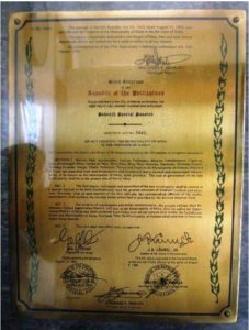
It was then Congressman Ricardo Y. Ladrido of the Fourth District of the Province of Iloilo, who authored and sponsored House Bill No. 16661 creating the Municipality of Mina in 1968. On 9 September 1968, R.A. No. 5442 was passed, declaring Mina as a municipality of the Province of Iloilo.
- Geographic Location and Land Area
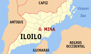
The Municipality of Mina is centrally located in the Province of Iloilo. Its geographic coordinates are as follows: 122°5’ longitude and 11° 5’. It is bounded on the north by the Municipality of Badiangan, east by the Municipality of Pototan, west by the Municipality of Janiuay, south by the Municipality of New Lucena, and southwest by the Municipality of Cabatuan (Map 1.1).
It takes about an hour to reach Mina by land from Iloilo City, and roughly about 30-40 minutes passing through Janiuay or Lucena and Pototan from the Iloilo International Airport. The town can also be accessed through the adjacent Municipality of Pototan on the east, or through a shorter route that traverses barangays Agmanaphao and Badiangan. Mina can also be accessed through the Municipality of Janiuay, and a shorter route through the Municipality of Cabatuan. The latter alternative direction would only take around 20 minutes from the boundary of Mina to the International Airport in Cabatuan, Iloilo.
Mina has a total land area of 4,340 hectares. Being predominantly agriculture, 97% of its land area is classified as rural. The remaining 3% is classified as urban comprise the two adjacent barangays (Mina East and Mina West, that constitute the Poblacion.
- Barangays of Mina
The Municipality’s territory is subdivided into 22 barangays: Barangay Abat, Agmanaphao, Amiroy, Badiangan, Bangac, Cabalabaguan, Capul-an, Dala, Guibuangan, (Janipa-an later was subdivided into) Janipa-an East and West, Mina, East, Mina West, Nasirum, Naumuan, Singay, Talipong Grande, Talibong Pequeno, Tipolo, Tolarucan, Tumay, Yugot. Only two barangays are urban and the 20 barangays are classified as rural. As the seat of local government, the Poblacion plays host to numerous government offices and commercial establishments which extends up to Barangay Cabalabaguan, where the main market is located. This is where the built-up area is concentrated. In terms of size, Barangay Badiangan is the largest occupying more than 12% of the total land area, while Barangay Mina West is the smallest covering 0.7% of the total land area.
Researched and compiled by Lydia E. Grabato and Dory P. Emelo
NAP records in Spanish language was translated by: Maria Luisa Garcia (ret) Editor & translator of Spanish documents to English, a cataloguer of National Archive of the Philippines
References:
- National Archive of the Philipines (NAP)
- Law of the United States Philippine Commission – Act 719
- Website of Research Center of Iloilo
- Documents from Monografias de los Pueblos de la Isla de Pan-ay of 1899 by Spanish historian Fray Juan Fernandez, OSA,
- Documents from University of San Agustin Library
- Documents from Archdiocese of Jaro, Iloilo
- Public Realm .word press.com
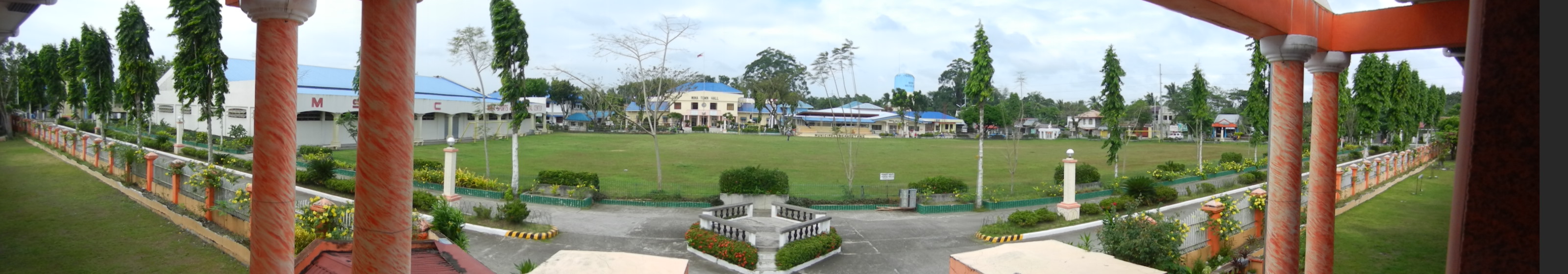
Mina Town Hall